Mineral Systems & Hydrocarbon Seepage Detection
Results-driven Geoscientist and Project Manager with 360-degree expertise in mineral and hydrocarbon exploration. I bridge the gap between advanced remote sensing and economic geology—transforming raw satellite/airborne imagery (Multispectral/Hyperspectral) into bankable exploration targets.
By applying supervised machine learning and deep learning architectures to spectral unmixing and lithological classification, I routinely reduce greenfield target zones by over 70% before field mobilization—saving millions in unproductive drilling, trenching, and seismic campaigns. I translate surface expressions (hydrothermal alteration halos, clay/iron-oxide vectors, and hydrocarbon micro-seepage/stress-induced lineaments) into quantifiable subsurface risk indicators, ensuring every field dollar is backed by robust spectral-geological evidence.

I help companies unlock the full potential of their data by providing expert data cleaning and preparation services specifically designed for AI and analytics. I systematically eliminate inconsistencies, handle missing values, merge duplicates, and standardize formats across diverse datasets. My approach is not just about cleaning—it’s about delivering data that is reliable, well-documented, and ready to drive insights. I’ve successfully prepared datasets ranging from small business spreadsheets to large-scale enterprise databases, consistently improving data quality and enabling faster, more accurate AI outcomes.
Bilingual leader (Spanish/English) with a track record of coordinating cross-functional field crews and delivering high-stakes technical presentations to boards and joint-venture partners.
CORE TECHNICAL CAPABILITIES (Business + Methods)
Team Leadership & Stakeholder Engagement:
Recruits and mentors geoscience specialists in AI-supported spectral interpretation and QC protocols. Delivers clear, data-backed technical reports and boardroom presentations in both Spanish and English—effectively communicating technical uncertainty and commercial upside to global teams. Critical Thinking and Curation. Goal and Context Engineering. Emotional Intelligence and Empathy. Adaptability and Unlearning.
Mineral Exploration Targeting (Greenfield & Brownfield):
Pinpoints hydrothermal alteration zones (phyllic, argillic, propylitic) and mineralization vectors using hyperspectral reflectance spectroscopy. Achieves a 70% reduction in Area of Interest (AOI) prior to boots-on-the-ground, enabling agile, low-cost reconnaissance.
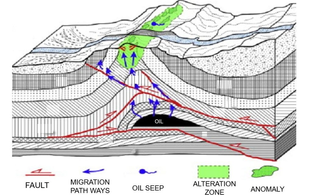
Hydrocarbon Seepage & Structural Analysis:
Identifies surface micro-seepage anomalies. Ranks plays and leads by integrating these surface proxies with regional basin models to lower exploration risk. Field Operations & Ground-Truthing.